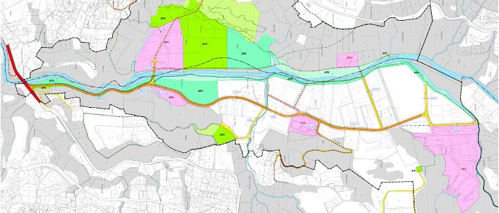
Intercommunal zoning plan of Piano della Stampa
The PRIPS (Piano regolatore intercomunale della Stampa) is a tool for programming territorial impact activities at the intercommunal level. It establishes urban planning policies to ensure correct evolution while respecting territorial, infrastructural, and environmental balances in an area in need of reorganization.

The Piano della Stampa is located on the outskirts of Lugano's urban area—beyond the New Cornaredo District (Nuovo Quartiere Cornaredo, NQC)—and covers an area of approximately 106 hectares. It extends along the alluvial plain of the Cassarate River and involves the territory of the City of Lugano (Districts of Davesco and Cadro) and the Municipality of Canobbio.
Starting from the 1970s, the area began experiencing disorganized development, both in urban planning and in the functions established there. This incoherence caused hydrogeological, environmental, and infrastructural problems. Between the late 1980s and early 1990s, based on the Cantonal strategic plan (Piano direttore cantonale), the first studies were promoted to address the absence of an integrated planning approach and to modify the territorial structure that for too long relegated Piano della Stampa to the status of a low-value area for "less noble" activities.
An Intercommunal zoning plan
With the opening of the eastern portal of the Vedeggio-Cassarate Tunnel and the development of the New Cornaredo District (Nuovo Quartiere Cornaredo, NQC), the location of Piano della Stampa has gained new significance and attracted increased interest. To harness the potential of the area, it is necessary to revise the area's planning to improve its overall urban, infrastructural, and environmental quality.
The municipalities of Lugano and Canobbio decided to join forces and proceed together to coordinate strategies and urban planning policies by adopting an Intercommunal zoning plan (Piano regolatore intercomunale). This plan would allow for the redesign of the area's shared content. The Intercommunal zoning plan of Piano della Stampa (PRIPS) was approved by the State Council in May 2018.
Objectives and main contents
The PRIPS is a tool for programming territorial impact activities at the intercommunal level. It establishes urban planning policies to ensure proper development while respecting territorial, infrastructural, and environmental balances in an area requiring reorganization.
Its main objectives are:
- Reorganize the territory and road network of Piano della Stampa;
- Improve and expand areas dedicated to sports and recreational activities;
- Establish new public and private activities, facilitated by improved accessibility from the Vedeggio-Cassarate Tunnel;
- Ensure the settlement of high-value-added activities (ranging from logistics to energy, material recycling, administrative services, service companies, industrial production, and laboratories);
- Enhance the landscape and environment, protecting natural sites (wetlands, buffer zones, etc.).
Thanks to the PRIPS, the role of Piano della Stampa within the Lugano urban hub is set to consolidate and improve, particularly in the artisanal and industrial sectors, hosting essential service activities for the City (warehouses, garages, services for companies and the urban agglomeration) and activities capable of economically enhancing the territory.
On the one hand, the plan will continue to accommodate—through appropriate urban planning corrections and in the context of improved regulatory conditions—artisanal uses that are struggling in the city's central areas (such as the New Cornaredo District (NQC) and the Cassarate riverside). On the other hand, conditions will be created to attract higher value-added activities, leveraging the strategic potential offered by the Vedeggio-Cassarate Tunnel.
The physical proximity and connections with the NQC, including pedestrian and cycling links, make it strategic for the City to promote leisure and recreational activities tied to existing sports facilities. This includes fostering synergies between these activities, improving usability, and enhancing the environmental and landscape quality of areas of natural interest, particularly the Cassarate River corridor.
The English version of this page was created with the aid of automatic translation tools and may contain errors and omissions.
The original version is the page in Italian.